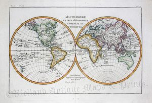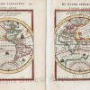
An interesting and attractive pair of late 17th century miniature maps of the Western and Eastern Hemispheres, respectively, (showing California* as an island) which were published in Alain Manesson Mallet’s Description de l’Univers (Paris: Denys Thierry, 1683).
*The Island of California was a long-held European misconception, dating from the 16th century, that stated the Baja California Peninsula was not part of mainland North America but rather a large island separated from the continent by a strait now known as the Gulf of California.One of the most famous cartographic errors in history, it was propagated on many maps during the 17th and 18th centuries, despite contradictory evidence from various explorers. The myth was further elaborated by the idea that California was a terrestrial paradise, similar to the Garden of Eden. The error was only finally settled beyond doubt by the expeditions of Juan Bautista de Anza who travelled between Sonora and the west coast of California in the period of 1774-1776.
- These are original copperplate engravings with later hand colour.
- Printed areas (engraving only) are approximately 10.5cms by 14.4cms for the Western Hemisphere and 10.1cms by 14.3cms for the Eastern.
- The maps are in very good condition with decent margins. Click on image for a better view.
- Click on’ Delivery Policy’ for postage costs.
- Guaranteed to be over 330 years old.