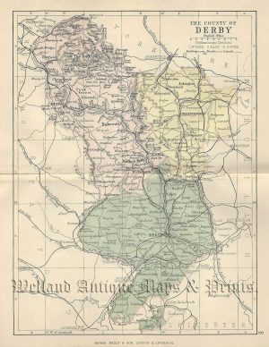
a very attractive and detailed 19th century map of Derbyshire, with a vignette view of Ashbourn Church, which appeared in Pigot & co.’s British Atlas* (Manchester & London: 1830-1835). The original page of text which accompanies this map is included in the purchase.
*The county maps from this series have the distinction of being the first to be produced from steel rather than copperplate. The rapid rise in the population in the 19th century had resulted in an increased demand for books and printed material. Copper, a comparatively soft metal, wasn’t durable enough to keep up with this, hence, the introduction of the more harder wearing steel.
- This is an original steel engraving with fine original hand colour.
- Printed area is approximately 22.4cms by 35.9cms (including imprint).
- The map is in very good condition with decent margins. Click on image for a better view.
- Click on ‘Delivery Policy’ for postage costs.
- Guaranteed to be over 175 years old.