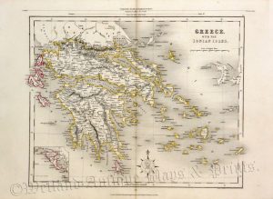
A detailed and decorative mid 19th century map of Southern Greece and the Ionian Islands which was drawn and engraved by J. Rapkin (vignettes by A. H. Wray and J. B. Allen) and published in John Tallis’s Illustrated Atlas (London & New York: c.1853). The original page of text which accompanies the map is included).
The Illustrated Atlas, published from 1849 onwards, was the last decorative world atlas. The ‘Ionian Isles and Greece’ map was typical of the many fine ones which appeared in this work with its decorative border and attractive vignettes. Illustrated are views of the Temple of Jupiter Olympus at Athens, an ancient war chariot, Greek corsairs off Corfu, wrestlers and a ‘modern Greek’.
- This is an original steel engraving with original hand colour.
- Printed area is approximately 31.7cms by 25.5cms (including imprint).
- The map is in very good condition with decent margins; centrefold, as issued. Click on image for a better view.
- Click on ‘Delivery Policy’ for postage costs.
- Guaranteed to be over 155 years old.