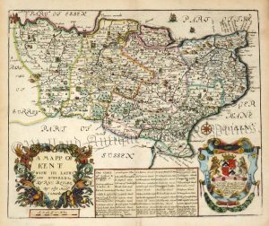
A highly decorative 19th century Thomas Moule map of Kent — with heraldic shields and vignette views of Greenwich Hospital, Rochester and Dover — which was published in Barclay’s Universal English Dictionary (London: G. Virtue, 1841-1849).
The Moule county maps were unusual for the period in that they were highly decorative. The scientific rationality of the late 18th & early 19th century had seen a move away from the flamboyance of earlier map making, emphasizing instead, a greater desire for accuracy and detail. Thomas Moule, like many of his contemporaries, however, was drawn to a more simplistic, pre-industrial age. This was clearly reflected in his maps with their neo-Gothic borders, heraldic shields and views of ancient buildings; ironically, the Moule maps issued later in the 1840s were amongst the first to show the newly constructed railways.
- This is an original steel engraving with later hand colour.
- Printed area is approximately 26.1cms by 19.7cms.
- The map is in very good condition with adwquate margins. There is a small repaired tear in the bottom left just entering the ‘ROCHESTER’ view. Click on image for a better view.
- The item comes displayed in a ready to frame museum quality mount.
- Click on ‘Delivery Policy’ for postage costs.
- Guaranteed to be over 170 years old.

!['KENT' by 'Reuben Ramble' (Rev. Samuel Clark) c.[1844?] 1845](https://www.wellandantiquemaps.co.uk/wp-content/uploads/2023/01/Kent-Ramble-001-copy-300x245.jpg)