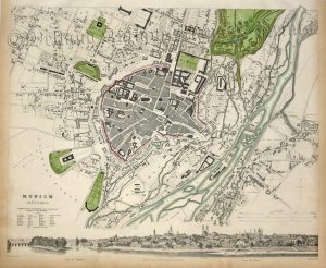
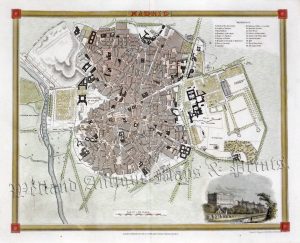
A very attractive and detailed mid 19th century city plan of Paris (on two joined sheets) which was drawn and engraved by W. B. Clarke and J. Shury, respectively, and published by the ‘Society for the Diffusion of Useful Knowledge’ (London: Baldwin & Craddock 1834). The plan is further embellished in the bottom border with various architectural images of the city’s prominent buildings including Notre Dame, the Hotel des Invalides and the Palais de Louvre.
‘The Society for the Diffusion of Useful Knowledge’ (S.D.U.K.), founded in 1826, was a philanthropist organisation established with the purpose of supplying the public with accessible and affordable educational material, particularly in the form of maps. The 19th century had, as a result of both the agricultural and industrial revolution, seen an increase in population, urbanisation and literacy. These resulting changes had lead to concerns that the urban masses could be influenced by cheap, radical and seditious forms of literature, which in turn, would lead to major social unrest and possible revolution. The S.D.U.K. sort to remedy this problem with more beneficial forms of education. Despite producing many fine works/maps and inspiring an American movement of the same name, the S. D. U. K. was to enjoy only moderate success and folded in 1848; nevertheless, its maps were republished by various publishers into the 1880s.
- This is an original steel engraving with original hand colour.
- Total printed area is approximately 52.3cms by 39.3cms (including imprint).
- The map is in very good condition with decent margins. There is age toning in the borders which stands out less in normal light. Click on image for a better view.
- Click on ‘Delivery Policy’ for postage costs.
- Guaranteed to be over 180 years old.