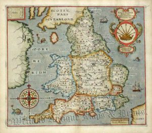
A detailed and finely engraved late 17th Century map of England & Wales by the Dutch cartographer Carel Allard
The map was produced soon after the ‘Glorious Revolution’ of 1688 which saw the ascension of the Protestant King William III and Queen Mary II over the deposed Catholic King, James II. In the cartouche, King William is personified as a Roman warrior with sword and shield ready to protect the realm whilst a crowned Queen Mary is seated with the orb and sceptre. The other classically inspired allegories may represent Protestantism.
On the map itself the main post roads are marked as are the bishoprics and archbishoprics. The two universities of Oxford and Cambridge are given a special conventional sign shared with Douai (Douey) on the continent. The original outline colouring shows the county boundaries but also, by different colour, the original seven Anglo-Saxon kingdoms.
“The maps designed by the Allards over the period 1680-1700 are well composed and up to date”. (Rodney W. Shirley, Printed Maps of the British Isles 1650-1750, 1988 p,23.)
- This is an original copperplate engraving with original & later hand colour
- Printed area is approximately 59cms by 50.5cms
- The map is in very good condition with adequate mountable borders Click on image for a better view.
- Fully insured postal delivery is included in the price
- Guaranteed to be over 300 years old.