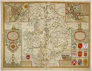
A very rare and decorative 17th century map of Warwickshire which was originally produced for William Smith* in c.1602 / 1603 (engraver: Jodocus Hondius) and then published later by John and Henry Overton in one of their composite atlases from c.1670 to c.1755. Pre-dating both the Saxton / Kip (1607) and the John Speed (1611-12), this is the earliest printed / detailed map dedicated solely to the county of Warwickshire.
William Smith* (1550-1618) was a renowned Elizabethan antiquarian and Officer of the College of Arms (Rouge Dragon Pursuivant). Looking to improve on the Saxton maps which were in circulation at the time, he planned to produce his own county atlas. He gave the task of engraving the map plates to the Amsterdam based map maker, Jodocus Hondius, who was one of the finest and most skilled engravers of the period.
By 1602 / 1603 a set of 12 county map plates had been completed including Surrey, Hertfordshire, Lancashire and Northamptonshire. The maps were an improvement on the ones by Saxton with extra place names, boundaries of hundreds and a more detailed map key. In spite of this, competition from the upcoming John Speed atlas saw Smith abandon his project. The plates were then acquired by Speed’s publishers, Sudbury & Humble, and were kept in storage never to be issued by them. Ironically, Hondius was to be made the master engraver for the Speed maps.
The Smith map plates finally reappeared on the market in the 1650s where they were acquired by the London publisher, Peter Stent, who sold them as individual maps. In 1665, Stent fell victim to the Great Plague and the plates were then acquired by John Overton who issued them (also later by his son, Henry) in various composite atlases from c.1670 up until c.1755. Owing to the rarity of Overton atlases, these are among the most difficult county maps to find and are highly collectible.
Until the mid 20th century, the authorship of the maps was unknown and they were subsequently known as the ‘Anonymous Maps’; a reference which is still used to this day.
- This is an original copperplate engraving.
- Printed area is approximately 45.7cms by 38.7cms.
- The map is in very good condition with decent margins; central fold, as issued. Click on image for a better view.
- Click on ‘Delivery Policy’ for postage costs.
- Guaranteed to be between 340 and 270 years old.