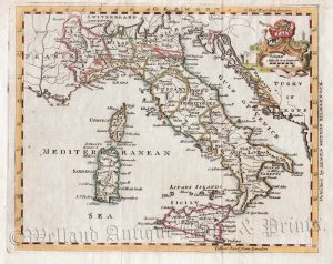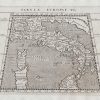
A very attractive and finely engraved late 16th / early 17th century map of Italy which appeared in Ptolemy’s Geographia, edited by Giovanni Magini (1617 Edition).
Giovanni Antonio Magini (1555-1617) was a prominent astronomer, astrologer, mathematician and cartographer. Born in Padua, he studied at the University of Bologna where he was eventually chosen in favour of Galileo to hold the position of chair of mathematics. In 1596, having written works on astronomy, he turned to cartography, editing a version of Ptolemy’s Geographia which included additional modern maps. The maps were finely engraved with fine italic script by Girolanio Porro (fl. 1567-1596), a distinguished Venetian engraver of the period. Despite their geographic shortcomings, the maps epitomised the high quality of Italian map making of that period.
Magini’s reputation as a map maker was further enhanced when he became the first Italian to prepare an atlas of his native country which was printed three years after his death in 1620.
- This is an original copperplate engraving.
- Printed area is approximately 16.7cms by 13cms.
- The map is in very good condition with decent borders. Click on image for a better view.
- Click on ‘Delivery Policy’ for postage costs.
- Guaranteed to be over 400 years old.