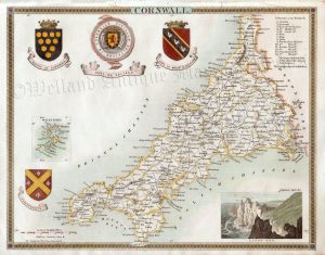
A detailed late 19th century map of Cornwall — with an inset of the Scilly isles — which was produced by John Bartholomew & Co. for Black’s Handy Atlas of England & Wales (London: A. & C. Black, 1892).
- This is an original late 19th century chromolithograph.
- Printed areas are approximately 24.5cms by 17.8cms
- The map is in very good condition with decent margins. Click on image for a better view.
- The item comes displayed in a ready to frame acid free mount.
- Click on ‘Delivery Policy’ for postage costs.
- Guaranteed to be over 125 years old.