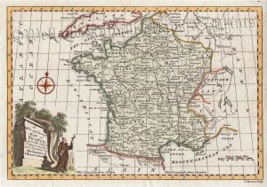
An attractive and detailed early 19th century map of France — with fine original hand colour and an attractive inset view of the Palace of Versaille — which was drawn by James Wyld, engraved by N. R. Hewitt and published in [Wyld’s] A General Atlas…from Original Drawings according to the Latest Treaties… (Edinburgh: John Thomson & co., 1823).
- This is an original copperplate engraving with original hand colour.
- Printed area is approximately 29.5cms by 23.5cms.
- The map is in very good condition with excellent margins. Click on image for a better view.
- Click on ‘Delivery Policy’ for postage costs.
- Guaranteed to be over 190 years old.
!['DEPT. DE LA CORSE.' [CORSICA] by Victor Levasseur c.1860s](https://www.wellandantiquemaps.co.uk/wp-content/uploads/2023/01/P1090549-copy-300x429.jpg)