

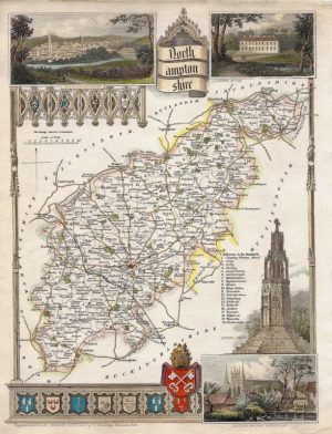
A very rare and attractive early 19th century map of Northamptonshire which appeared in Darton & Dix’s A Complete Atlas Of The English Counties (London: William Darton & Son, c.1835). The maps from this series are noteworthy for their richness of detail, engraving quality, fine original hand colour and quaint vignette view — in the case of Northamptonshire this is of the church and school house at Higham Ferrers. Despite their quality, the Darton & Dix maps are amongst the rarest county maps to find and are much sought after by collectors.
- This is an original copperplate engraving with fine original hand colour.
- Printed area is approximately 43.7cms by 35.4cms (including imprint).
- The map is in very good condition with decent margins; centrefolded, as issued. There is some very minor offset. Click on image for a better view.
- Click on ‘Delivery Policy’ for postage costs.
- Guaranteed to be over 175 years old.

!['NORTHAMPTONSHIRE' by 'Reuben Ramble' (Rev. Samuel Clark) c.[1844?] 1845](https://www.wellandantiquemaps.co.uk/wp-content/uploads/2023/01/Northants-Ramble-001-copy-300x380.jpg)
