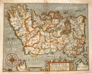
A very attractive and interesting 19th century map of Ireland which was printed by J. Bartholomew and published in Black’s General Atlas of the World (Edinburgh: A. & C. Black, 1864). An interesting feature of the map is the extensive railway network system which had been established in Ireland by that time.
John Bartholomew & co. were, during the 19th century, one of the world’s leading producers of maps and atlases. Established in 1826 by John Snr., the firm soon earnt a reputation for its fine craftmanship and quality. The business continued to prosper under John Jnr. who introduced innovative production techniques including colour contouring (hypsometric tinting). It remained a family business with a renown for excellence well into the 20th century, The ‘Times Survey Atlas of the World’ being one of its notable achievements . The company became a sudsidary of HarperCollins in 1989.
- This is an original chromolithograph (lithographic transfer printed with colour).
- Printed area is approximately 39cms by 50.8cms.
- The map is in very good condition with decent margins. Click on image for a better view.
- Click on ‘Delivery Policy’ for postage costs.
- Guaranteed to be over 140 years old.