

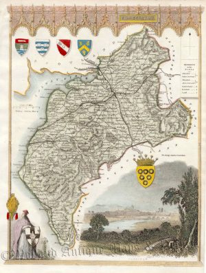
An attractive and detailed 19th century map of Cumberland — with a fine vignette view of Carlisle from the north-east — which was drawn and engraved by Gray & Son (vignette by R. Scott) and published by Archibald Fullarton & co. in A New And Comprehensive Gazetteer of England and Wales (Glasgow: Fullarton & co., 1836).
- This is an original steel engraving with later hand colour.
- Printed area is approximately 18.9cms by 24.2cms.
- The map is in very good condition with excellent margins; horizontal folds, as issued. Click on image for a better view.
- The item comes displayed in a ready to frame museum quality mount.
- Click on ‘Delivery Policy’ for postage costs.
- Guaranteed to be over 175 years old.
!['CUMBERLAND' by 'Reuben Ramble' (Rev. Samuel Clark) c.[1844?] 1845](https://www.wellandantiquemaps.co.uk/wp-content/uploads/2023/01/Cumberland-Ramble-001-copy-300x379.jpg)

