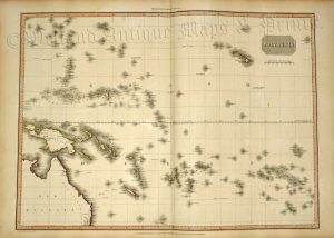
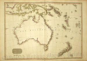
A very attractive, finely engraved and rare early 19th century map of the Pacific Ocean which was published in Sydney Hall’s A New General Atlas (London: Longman, Rees, Orme, Brown & Green; 1828-1830 [first edition]). A note on the map next to the Pitcairn Islands reads: “This Island is inhabited by the children of some of the Mutineers of the Bounty who after going to Otaheite [Tahiti], where they married some of the Otaheitans, settled here in 1790.” whereas another note next to the Sandwich Islands (now Hawaii) states “here Capt. Cook was killed on Sunday Feb. 14th 1779”. This historically interesting and highly collectable map was produced by Sydney Hall (1788-1831) who was one of the most recognised and prolific British map engravers at the time when Britain excelled in map making.
- This is an original copper engraving with fine original hand colour.
- Printed area is approximately 51.6cms by 41.6cms (folio).
- The map is in very good condition with excellent margins. There is a split to the bottom centrefold not affecting the printed area and some minor offset. Click on image for a better view.
- Click on ‘Delivery Policy’ for postage costs.
- Guaranteed to be over 180 years old.