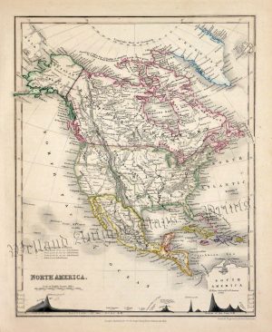
A very decorative and historically interesting mid 19th century map of North America*, with original hand colour, which appeared in Victor Levasseur’s Atlas National Illustré (Paris: Pelissier, 1846). Published between 1842 and 1872, Victor Levasseur’s ‘Atlas National’ was one of the most decorative and visually striking atlases of the 19th century. The map of North America exemplified this with its aesthetic and allegorical imagery.
*At the time of this map’s publication, Texas was an independent country having achieved this from Santa Anna’s Mexico in 1836. This was to change when Texas was admitted to the United States in 1846 which in turn, prompted the Mexican-American War (1846-1848). The ensuing American victory resulted in the annexation of 55% of Mexican territory including what would become the modern day States of California, Nevada, Utah, Arizona and New Mexico as well as parts of Colorado, Wyoming, Oklahoma and Kansas.
The map also displays American claims to what what is now British Colombia, Canada prior to the signing to the Oregon Treaty in 1846. The future State of Alaska meanwhile, was Russian territory meaning that at one time this country covered three continents. Alaska was eventually sold to the United States in 1867 at the price of $7.2 million or two cents an acre.
- Printed area is approximately 43.5cms by 31.1cms (including imprints).
- The map is in very good condition with decent margins. Click on image for a better view.
- Click on ‘Delivery Policy’ for postage costs.
- Guaranteed to be over 170 years old.