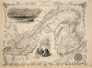
A very attractive, finely engraved and rare early 19th century map of ‘British North America’ (now Canada) which was published in Sydney Hall’s A New General Atlas (London: Longman, Rees, Orme, Brown & Green; 1827-1830 [first edition]).
At the time of the maps production a large part of the Canadian Arctic still remained unexplored thus maintaining the belief that a navigable Northwest passage existed. The original owner of this map makes reference to John Ross’s recent expedition of 1818 with a pencilled note mentioning a “North passage to the Southward…Capt. Ross”. The limited geographic knowledge is further illustrated by the mistaken belief that Ellesmere Island (then ‘North Devon’) is joined to Greenland. Elsewhere, American claims to lands north of the 49th parallel are illustrated whereas modern day Alaska is still ‘RUSSIAN TERRITORY’. This highly collectable and historically important map was produced by Sydney Hall (1788-1831) who was one of the most recognised and prolific British map engravers at the time when Britain excelled in map making.
- This is an original copper engraving with fine original hand colour.
- Printed area is approximately 51.7cms by 41.6cms including imprint (folio).
- The map is in very good condition with excellent margins. There is a split to the bottom centrefold which enters the border and there is some minor offset. Click on image for a better view.
- Click on ‘Delivery Policy’ for postage costs.
- Guaranteed to be over 180 years old.