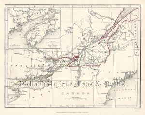
A detailed and attractive 19th century map of the Quebec region of Canada — with an inset plan of the Environs of Montreal — which appeared in Mitchell’s New General Atlas (Pennsylvania: S. A. Mitchell Jr., 1860).
- This is an original steel engraving / lithographic transfer with original hand colour.
- Printed area is approximately 33.6cms by 27cms
- The print is in very good condition with decent margins. Click on image for a better view.
- Click on ‘Delivery Policy’ for postage costs.
- Guaranteed to be over 150 years old.