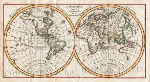
An interesting and attractive small 18th century double hemishere map of the World depicting California* as an island which was published in P. [Claude] Buffier’s Geographe Univerelle (Paris: Pierre-François Giffart, 1769).
*The Island of California was a long-held European misconception, dating from the 16th century, that stated the Baja California Peninsula was not part of mainland North America but rather a large island separated from the continent by a strait now known as the Gulf of California.One of the most famous cartographic errors in history, it was propagated on many maps during the 17th and 18th centuries, despite contradictory evidence from various explorers. The myth was further elaborated by the idea that California was a terrestrial paradise, similar to the Garden of Eden. The error was only finally settled beyond doubt by the expeditions of Juan Bautista de Anza who travelled between Sonora and the west coast of California in the period of 1774?1776.
- This is an original copperplate engraving with later hand colour.
- The approximate size of the printed area is 17.3cms by 13.3cms.
- The map is in very good condition with adequate margins, vertical fold, as issued. Click on image for a better view.
- The item comes displayed in a ready to frame museum quality mount.
- Click on ‘Delivery Policy’ for postage costs.
- Guaranteed to be over 250 years old.