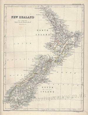
A detailed and attractive late 19th century map of New Zealand — with a vignette view of the Southern Alps — which was produced by W. & A. K. Johnston and published in [Alexander Keith Johnston’s] Handy Royal Atlas of Modern Geography (Edinburgh & London: William Blackwood & Sons, 1868).
- This is an original chromolithograph (lithographic transfer).
- Printed area is approximately 33cms by 43.2cms (including imprint).
- The map is in very good condition with decent margins. Click on image for a better view.
- Click on ‘Delivery Policy’ for postage costs.
- Guaranteed to be over 150 years old.