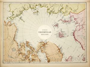
A decorative, detailed and spectacular mid 19th century map of the Arctic Regions which was published The Royal Illustrated Atlas of Modern Geography (London & Edinburgh: A. Fullarton & co.,1862-1872).
This historically interesting map refers to the fabled North-West passage which would have allowed shipping to travel faster to Asia without the need to circumnavigate South America. The many vignettes refer to the hazards sailing in the Arctic Ocean; the various fauna, including seals and polar bears; and the native people engaged in various activities including hunting, sledging and building a ‘snow hut’.
- This is a 19th century lithographic transfer with original outline colour.
- Printed area is approximately 30.5cms by 46.8cms (including title and imprint).
- The map is in very good condition. with decent margins. The left margin is shaved, as issued and there is overall age toning. Click on image for a better view.
- Click on ‘Delivery Policy’ for postage costs.
- Guaranteed to be over 150 years old.