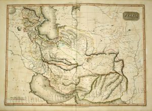
An interesting and attractive mid 19th century map covering the Arabian Peninsula, the Middle East and modern day Iran which appeared in G. F. Cruchley’s General Atlas for the Use of Schools and Private Tuition (London: G. F. Cruchley, 1842/1843).
- This is an original lithographic transfer (from an engraving) with fine original hand colour.
- Printed area is approximately 44.6cms by 36.4cms (including imprint).
- The print is in very good condition with adequate margins; centre fold, as issued. Click on image for a better view.
- Click on ‘Delivery Policy’ for postage costs.
- Guaranteed to be over 150 years old.