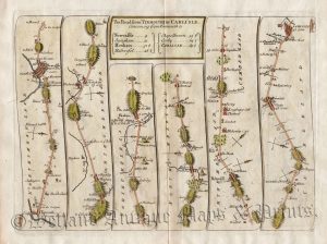
Actual Title: ‘The Continuation of the Road from LONDON to ST. DAVIDS cos Pembroke Comencing at Burton Ferry and extending to ST. DAVIDS By THO.s GARDNER.’
An interesting and rare early 18th century road strip map showing the route from Briton Ferry to St. Davids — via Llaneli, Kidwelly, Llansteffan and Haverfordwest — which was published in Thomas Gardner’s A Pocket-Guide To The English Traveller (London: J. Tonson & J. Watts, 1719).
Based on John Ogilby’s Britannia c.1675, Gardner’s road strip maps were of a reduced size making them more practical for the traveller. His atlas was, however, published only once making the maps rare to find.
- This is an original copperplate engraving with later hand colour.
- Printed area is approximately 26.9cms by 16.1cms.
- The map is in very good condition with decent margins. Click on image for better view.
- The item comes displayed in a ready to frame museum quality mount.
- Click on ‘Delivery Policy’ for Postage costs.
- Guaranteed to be over 300 years old.
![Plate 34 [94*]: The Road from Hatherleigh to Truro (via Launceston) by Thomas Gardner c.1719](https://www.wellandantiquemaps.co.uk/wp-content/uploads/2023/01/Plate-34094-Gardiner-Hatherley-Truro-01-001-copy-300x187.jpg)