Skip to content
Register
Login
Home
About Us
Contact Us
Feedback
Recent Additions
Shop Online
Login
Register
£
0.00
Search for:
Search
Our Range
Antique Maps
Fairy Range
Other Prints
Topography
English Topography
Foreign Topography
Irish Topography
Scottish Topography
Welsh Topography
Anglesey Prints
Caernarfonshire Prints
Cardiganshire Prints
Carmarthenshire Prints
Denbighshire Prints
Flintshire Prints
Glamorgan Prints
Merionethshire Prints
Monmouthshire Prints
Montgomeryshire Prints
Pembrokeshire Prints
Welsh Road Maps
Home
/
Topography
/
Welsh Topography
/ Welsh Road Maps
Welsh Road Maps
Original Antique Road Maps Running Through Wales.
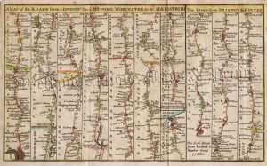
‘A MAP of the ROADS from LONDON thro OXFORD, WORCESTER &c. to ABERISTWITH’ / ‘The ROAD from BRISTOL to EXETER’ by Gent. Mag. c.1765
£
85.00
Add to basket
Add to Wishlist
Add to Wishlist
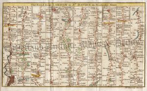
‘The Road from LONDON to ST. DAVIDS in Pembroke Shire.’ by T. Bowen / Gent. Mag. c.1765-1774
£
80.00
Add to basket
Add to Wishlist
Add to Wishlist
Out of stock
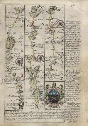
Page 37 & 38: The Road from Monmouth to Aberavon / Port Talbot (via Cardiff) by J. Owen & E. Bowen c.1720-1764
£
38.00
Read more
Add to Wishlist
Add to Wishlist
Page 39 & 40: The Road from [Burton] Port Talbot to St. Davids (via Swansea & Haverfordwest) by J. Owen & E. Bowen c.1724
£
38.00
Add to basket
Add to Wishlist
Add to Wishlist
Plate 17: The Road from Briton Ferry to St. Davids (via Swansea) by Thomas Gardner c.1719
£
65.00
Add to basket
Add to Wishlist
Add to Wishlist
Plate 3: The Road from Bromyard to Aberystwith (via Leominster & Presteigne) by Thomas Gardner c.1719
£
65.00
Add to basket
Add to Wishlist
Add to Wishlist
Plate 64: The Road from Llanbadarn Fynydd to Cardiff (via Brecon) by Thomas Gardner c.1719
£
65.00
Add to basket
Add to Wishlist
Add to Wishlist
Home
About Us
Contact Us
Feedback
Recent Additions
Shop Online
Login
Register
Shopping Basket
Scroll to Top


![Page 39 & 40: The Road from [Burton] Port Talbot to St. Davids (via Swansea & Haverfordwest) by J. Owen & E. Bowen c.1724](https://www.wellandantiquemaps.co.uk/wp-content/uploads/2023/01/Owen-Bowen-39-copy-300x434.jpg)