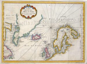
!['POLOGNE [Poland]Par le S Robert de Vaugondy' c.1750-1780](https://www.wellandantiquemaps.co.uk/wp-content/uploads/2025/01/Poland-Vaugondy-Method-Abregee-01-ed.jpg)
An interesting 18th century map of Poland which was originally produced by Gilles [Le Sieur] Robert de Vaugondy and published in Methode Abregee et Facile Pour Apprendre La Geographie (Paris: Chez Les Libraires Associés, c.1780).
- This is an original copperplate engraving with later hand colour.
- Printed area is approximately 16.9cms by 15.8cms.
- The map is in very good condition with adequate margins; vertical folds, as issued. Click on image for a better view.
- The item comes displayed in a ready to frame museum quality mount.
- Click on ‘Delivery Policy’ for postage costs.
- Guaranteed to be over 200 years old.