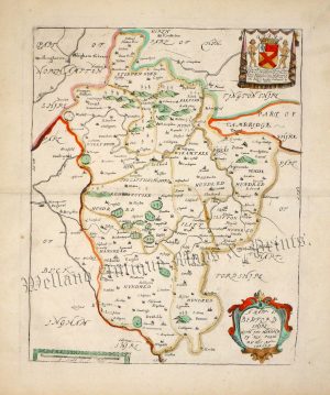
An interesting, highly decorative and very rare Saxton / Lea map of the combined counties of Northamptonshire, Rutland, Bedfordshire and Huntingdonshire — with inset plans of Northampton, Peterborough, Huntingdon, Oakham and Bedford — which was published by George Willdey in The Shires of England and Wales (London: c.1732).
This map was originally published in Christopher Saxton’s untitled county atlas of 1579 (which happened to be the first ever national and county atlas). A century later the map was given a new lease of life when the publisher Philip Lea acquired and updated the Saxton plates to include roads (taken from Ogilby’s Britannia), town plans (from John Speed’s Theatre) the boundaries of the hundreds, heraldic shields and English text. The maps were subsequently republished by George Willdey (c.1732), Thomas Jefferys (c.1749) and finally Dicey & co. (c.1770s) giving them a publication life of approximately 200 years.
- This is an original copperplate engraving with original and later hand colour.
- Printed area is approximately 53cms by 40cms.
- The map is in very good condition with decent margins. There are a few minor printer’s creases. Click on image for a better view.
- Click on ‘Delivery Policy’ for postage costs.
- Guaranteed to be over 275 years old.