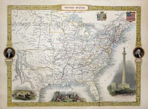
An attractive and detailed mid 19th century map of the United States of America (pre Civil War) which was produced as A.K. Johnston and published in the A School Atlas of General and Descriptive Geography (Edinburgh & London: William Blackwood & Sons, 1857).
- This is an original Chromolithograph.
- Printed area is approximately 31.9cms by 24.2cms (including imprint).
- The item is in very good condition with decent margins; centrefold, as issued. Click on image for a better view.
- Click on ‘Delivery Policy’ for postage costs.
- Guaranteed to be over 160 years old.