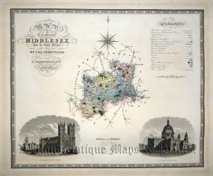
A detailed and very attractive early 19th century map of London and its environs which was drawn and engraved by R. Creighton and J. & C. Walker respectively, and published in Samuel Lewis’s Topographical Dictionary of England (London: S. Lewis, 1835). At the time of the map’s publication, London had become the largest city in the World with a population of approximately two million.
- This is an original steel engraving with later hand colour.
- Printed area is approximately 46.8cms by 39cms (including title & imprint).
- The map is in very good condition with decent margins; horizontal and vertical folds as issued. There is a an inconspicuous tear in the left border and a split in the top right vertical fold has been repaired. Click on image for a better view.
- Click on ‘Delivery Policy’ for postage costs.
- Guaranteed to be over 185 years old.