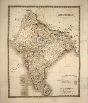
A highly decorative and detailed mid 19th century map of India (including Nepal) which was drawn and engraved by J. Rapkin (vignettes by A. H. Wray & G. Greenbach) and published in John Tallis’s Illustrated Atlas (London & New York: c.1851). An interesting feature of the map is the depiction of the then proposed railway lines running from Bombay to Delhi and Calcutta. From the first opening in 1853, the railway network has become an integral feature of modern India.
The Illustrated Atlas, published from 1849 to 1853, was the last decorative world atlas. The ‘British India’ map was typical of the many fine ones which appeared in this work with its decorative border and attractive vignettes. Illustrated are views of Lahore; Cootub Minar, Delhi; an Indian procession and Belouche tribesmen.
- This is an original steel engraving with original hand colour.
- Printed area is approximately 25cms by 33.8cms (including imprint).
- The map is in very good condition with decent margins. Click on image for a better view.
- Click on ‘Delivery Policy’ for postage costs.
- Guaranteed to be over 155 years old.