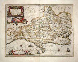
A very attractive and finely engraved 17th century map of Dorset which was printed and published by Jan Jansson for his Atlas Novus (Amsterdam: [Blank verso] 1646-1666). Jansson was one of the leading Dutch map makers during the period in which the Netherlands led the World in commerce, art, science and especially, cartography.
Interestingly, on the reverse of the map, the publisher or original owner has written in ink the name of the county in an elegant 17th century style (see above image).
- This is an original copperplate engraving with fine later hand colour.
- Printed area is approximately 49cms by 37.7cms.
- The map is in very good condition with excellent margins. The paper is slightly age toned — as with all Jansson maps. There a couple of inconspicuous parallel creases running up the right side of the map. Click on image for a better view.
- Click on ‘Delivery Policy’ for postage costs.
- Guaranteed to be over 350 years old.