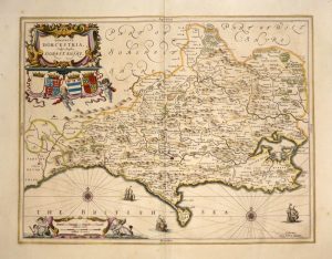
A very attractive, finely engraved and delicately hand coloured 17th century map of Dorset which was printed and published by Jan Jansson for his Atlas Novus (Amsterdam: [Latin Text Edition] 1646-1659).
Jan Jansson (Latin: Johannes Janssonius 1588-1664) was one of the leading Dutch map makers during the period in which the Netherlands led the world in commerce, art, science and especially, cartography. Born in Arnhem, the son of a noted bookseller and publisher, he moved to Amsterdam and married in 1612 the daughter of the renowned cartographer Jodocus Hondius (1563-1612). In partnership with his brothers-in-law, Jodocus (the younger) and Henricus, he began publishing maps in great quantity and of a high standard. With the deaths of Jodocus in 1629 and Henricus in 1638, he became sole proprietor and embarked on a project to produce a world atlas that would rival even Blaeu’s ‘Atlas Novus’. In 1646 he produced an English County Atlas to compete with Blaeu’s version published the previous year. In appearance, the maps from both atlases are similar, but whilst Blaeu’s are slightly better engraved, Jansson’s are noted for being more flamboyant and, arguably, more decorative. After Jansson’s death, his work was published by his heirs and then by subsequent publishers well into the 18th century.
- This is an original copperplate engraving with fine original hand colour.
- Printed area is approximately 49.6cms by 37.9cms.
- The map is in very good condition with decent margins; centre fold, as issued. Slight staining and age toning, as with most Jansson maps. Click on image for a better view.
- Click on ‘Delivery Policy’ for postage costs.
- Guaranteed to be over 350 years old.