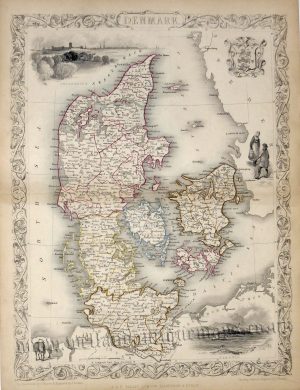
A detailed early 19th century map of Denmark, with insets of Iceland and the Faroe Islands, which was engraved by W. Dassauville and published in John Thomson’s New General Atlas of the World (Edinburgh: John Thomson & Co., c.1814-1828).
John Thomson (1777-1837) was an Edinburgh based Scottish cartographer and publisher. Along with names such as John Pinkerton and John Cary, he redefined early 19th century cartography and helped establish Britain as the world leader in map making. Whereas earlier maps had had an ornamental charm, Thomson’s were based on a scientific rationale that demanded detail, quality and accuracy. His most celebrated work was his ”New General Atlas’ which was published from 1814 to 1828 and is particularly noted for its fine original hand / wash colour.
- This is an original copper engraving with fine original hand colour.
- Printed area is approximately 59.6cms by 51.5cms.
- The map is in very good condition with decent margins. Click on image for a better view.
- Click on ‘Delivery Policy’ for postage costs.
- Guaranteed to be over 185 years old.