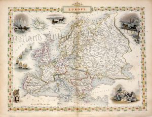
A decorative and detailed mid 19th century map of Europe which was drawn and engraved by J. Rapkin (vignettes by J. Marchant & J. Rogers) and published in John Tallis’s Illustrated Atlas (London & New York: John Tallis & co, c.1851).
The Illustrated Atlas, published from 1849 onwards, was the last decorative world atlas. The map of ‘Europe’ was typical of the many fine ones which appeared in this work with its decorative border and attractive vignettes. Illustrated are views of Russians and Laplanders travelling in sleighs, a hunter in a canoe hunting seal, a dismounted Arab with a dromedary camel and poignantly, an Arabian slave market.
- This is an original steel engraving with original hand colour.
- Printed area is approximately 32cms by 26.2cms (including imprint).
- The map is in very good condition with decent margins; centrefold, as issued. Click on image for a better view.
- Click on ‘Delivery Policy’ for postage costs.
- Guaranteed to be over 160 years old.