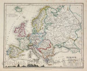
A detailed and attractive 19th century miniature map of Europe, with fine original wash colour, which was engraved by Thomas Starling and published in either The Royal Cabinet Atlas or Geographical Annual (London: Bull & Churton, 1830/1832). A table listing all the principal cities of Europe is included.
- This is an original steel engraving with original hand colour.
- Printed area is approximately 14.6cms by 9.3cms (including imprint).
- The engraving is in very good condition with decent margins. Click on image for a better view.
- The item comes displayed in a ready to frame acid free mount.
- Click on ‘Delivery Policy’ for postage costs.
- Guaranteed to be over 180 years old.