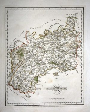
A rare and attractive early 18th Century map of Gloucestershire which was originally produced by Robert Morden in c.1701 (engraver: I. Harris) and then published in Thomas Cox’s Magna Britannia et Hibernia (London: 1717-1738).
- This is an original copperplate engraving with later hand colour.
- Printed area is approximately 20.1cms by 15.3cms.
- The map is in very good condition with decent margins; vertical folds, as issued. Click on image for a better view.
- The item comes displayed in a ready to frame museum quality mount.
- Click on ‘Delivery Policy’ for postage costs.
- Guaranteed to be over 275 years old.