Skip to content
Register
Login
Home
About Us
Contact Us
Feedback
Recent Additions
Shop Online
Login
Register
£
0.00
Search for:
Search
Our Range
Antique Maps
County Maps
Bedfordshire Maps
Berkshire Maps
British Islands
Buckinghamshire Maps
Cambridgeshire Maps
Cheshire Maps
Cornwall Maps
Cumberland Maps
Derbyshire Maps
Devon Maps
Dorset Maps
Durham Maps
Essex Maps
Gloucestershire Maps
Hampshire Maps
Herefordshire Maps
Hertfordshire Maps
Huntingdonshire Maps
Kent Maps
Lancashire Maps
Leicestershire Maps
Lincolnshire Maps
Middlesex Maps
Norfolk Maps
Northamptonshire Maps
Northumberland Maps
Nottinghamshire Maps
Oxfordshire Maps
Rutland Maps
Scottish Counties & Regions
Shropshire Maps
Somerset Maps
Staffordshire Maps
Suffolk Maps
Surrey Maps
Sussex Maps
Warwickshire Maps
Welsh Maps
Westmorland Maps
Wiltshire Maps
Worcestershire Maps
Yorkshire Maps
Foreign Maps
Great Britain & Ireland with Regional Maps
Renowned Map Makers
Road Maps
Title Pages / Frontispieces
Town Plans
Fairy Range
Other Prints
Topography
Home
/
Antique Maps
/
County Maps
/ Gloucestershire Maps
Gloucestershire Maps
Original Antique Maps of Gloucestershire from the 17th to 19th Century
.
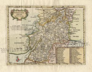
‘A Map of GLOCESTER-SHIRE [Gloucestershire] North West from London’ by T. Badeslade / W. H. Toms c.1742
£
70.00
Add to basket
Add to Wishlist
Add to Wishlist
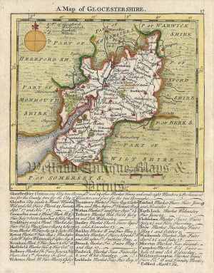
‘A MAP of GLOUCESTERSHIRE.’ by T. Kitchin / T. Jefferys c.1751
£
90.00
Add to basket
Add to Wishlist
Add to Wishlist
‘A New & correct Map of the Counties of GLOCESTER & MONMOUTH Engraved from an actual Survey.’ by John Harrison c.1786-1791
£
110.00
Add to basket
Add to Wishlist
Add to Wishlist
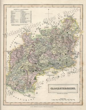
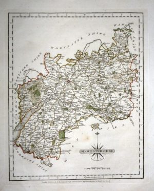
‘A New MAP of GLOCESTER SHIRE [Gloucestershire], Drawn from the best Authorities’ by Thomas Kitchin c.1764
£
95.00
Add to basket
Add to Wishlist
Add to Wishlist
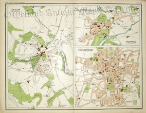
‘BUXTON’. ‘WARWICK’, ‘CHELTENHAM’ by John Bartholomew c.1898
£
30.00
Add to basket
Add to Wishlist
Add to Wishlist
Out of stock
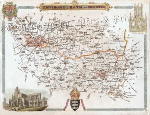
‘ENVIRONS OF BATH AND BRISTOL’ by Thomas Moule c.1840s
£
60.00
Read more
Add to Wishlist
Add to Wishlist
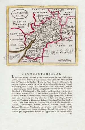
‘GLOCESTER SHIRE’ (Gloucestershire) by J. Owen & E. Bowen c.1724
£
60.00
Add to basket
Add to Wishlist
Add to Wishlist
‘GLOCESTER SHIRE’ by John Bill c.1626
£
425.00
Add to basket
Add to Wishlist
Add to Wishlist
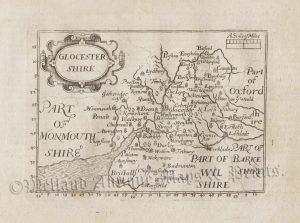
‘GLOCESTER SHIRE’ by R. Morden / T. Cox c.1717-1738 (‘Small Morden’)
£
95.00
Add to basket
Add to Wishlist
Add to Wishlist
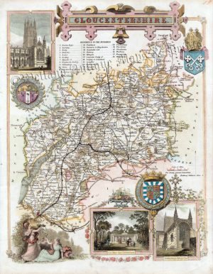
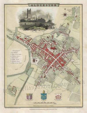
‘GLOCESTER’ (Gloucester) by G. Cole & J. Roper c.1805 / 1810
£
105.00
Add to basket
Add to Wishlist
Add to Wishlist
‘GLOCESTERSH.’ (Gloucestershire) c.1821
£
36.00
Add to basket
Add to Wishlist
Add to Wishlist
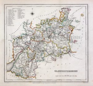
‘GLOCESTERSH.’ [Gloucestershire] by ‘Reuben Ramble’ (Rev. Samuel Clark) c.[1844?] 1845
£
95.00
Add to basket
Add to Wishlist
Add to Wishlist
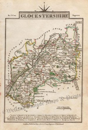
‘GLOCESTERSHIRE By JOHN CARY Engraver.’ c.1787 (New & Correct English Atlas)
£
65.00
Add to basket
Add to Wishlist
Add to Wishlist
‘GLOCESTERSHIRE By JOHN CARY Engraver.’ c.1818 (New & Correct English Atlas)
£
70.00
Add to basket
Add to Wishlist
Add to Wishlist
‘GLOCESTERSHIRE’ (Gloucestershire) by J. Archer / T. Johnson c.1863
£
40.00
Add to basket
Add to Wishlist
Add to Wishlist
‘GLOCESTERSHIRE’ (Gloucestershire) by J. Archer / W. Pinnock c.1837
£
25.00
Add to basket
Add to Wishlist
Add to Wishlist
Out of stock
‘GLOCESTERSHIRE’ (Gloucestershire) by J. Cary c.1810
£
32.00
Read more
Add to Wishlist
Add to Wishlist
‘GLOCESTERSHIRE’ (Gloucestershire) by James Wallis c.1816-1819
£
30.00
Add to basket
Add to Wishlist
Add to Wishlist
‘GLOCESTERSHIRE’ [Gloucestershire] (with full original wash colour) by G. Cole & J. Roper c.1805 / 1810
£
48.00
Add to basket
Add to Wishlist
Add to Wishlist
‘GLOCESTERSHIRE’ [Gloucestershire] by G. Cole & J. Roper c.1805 / 1810
£
48.00
Add to basket
Add to Wishlist
Add to Wishlist
‘GLOCESTERSHIRE.’ (Gloucestershire) by H. Teesdale (R. Rowe) c.1832
£
75.00
Add to basket
Add to Wishlist
Add to Wishlist
‘GLOCESTERSHIRE.’ (with text) by Sidney Hall c.1833
£
45.00
Add to basket
Add to Wishlist
Add to Wishlist
‘GLOCESTERSHIRE.’ by Fullarton & Co. / Gray & Son c.1843
£
48.00
Add to basket
Add to Wishlist
Add to Wishlist
‘GLOCESTRIA DUCATUS; GLOCESTER SHIRE.’ (Gloucestershire) by Joan Blaeu c.1645 (Latin Text Edition)
£
475.00
Add to basket
Add to Wishlist
Add to Wishlist
‘GLOCESTRIAE Comitatus olim sedes DOBUNORUM’ (Gloucestershire) by C. Saxton / W. Hole c.1637
£
325.00
Add to basket
Add to Wishlist
Add to Wishlist
‘GLOuCESTER SHIRE By Rob.t Morden’ c.1722
£
200.00
Add to basket
Add to Wishlist
Add to Wishlist
‘GLOUCESTER SHIRE Divided into its HUNDREDS’ by E. Bowen c.1758 / 1763
£
110.00
Add to basket
Add to Wishlist
Add to Wishlist
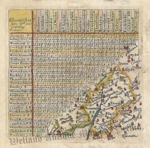
‘Gloucester Shire w.th some confining Towns’ by Jacob Van Langeren c.1643-1657
£
100.00
Add to basket
Add to Wishlist
Add to Wishlist
‘Gloucester Shire w.th some confining Towns’ by Jacob Van Langeren c.1643-1657
£
95.00
Add to basket
Add to Wishlist
Add to Wishlist
‘GLOUCESTER-SHIRE.’ by Thomas Read (John Rocque) c.1769
£
75.00
Add to basket
Add to Wishlist
Add to Wishlist
Out of stock
‘GLOUCESTERSHIRE’ (Hobson Fox Hunting Map) By J. & C. Walker c.1850
£
50.00
Read more
Add to Wishlist
Add to Wishlist
‘GLOUCESTERSHIRE’ (with Triangular Distance Table) by James Pigot (Pocket Topography) c.1841
£
55.00
Add to basket
Add to Wishlist
Add to Wishlist
‘GLOUCESTERSHIRE’ by Creighton / Walker /Lewis c.1840
£
40.00
Add to basket
Add to Wishlist
Add to Wishlist
‘GLOUCESTERSHIRE’ by Joshua Archer / Thomas Dugdale c.1842
£
35.00
Add to basket
Add to Wishlist
Add to Wishlist
‘GLOUCESTERSHIRE’ by Joshua Archer c.1860
£
35.00
Add to basket
Add to Wishlist
Add to Wishlist
‘GLOUCESTERSHIRE’ by Leigh / Hall c.1835
£
30.00
Add to basket
Add to Wishlist
Add to Wishlist
‘GLOUCESTERSHIRE’ by Thomas Moule c.1840s
£
80.00
Add to basket
Add to Wishlist
Add to Wishlist
‘GLOUCESTERSHIRE.’ by Pigot & co. c.1840
£
110.00
Add to basket
Add to Wishlist
Add to Wishlist
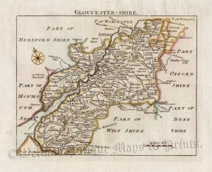
‘GLOUCESTERSHIRE.’ by Seller / Grose c.1800
£
60.00
Add to basket
Add to Wishlist
Add to Wishlist
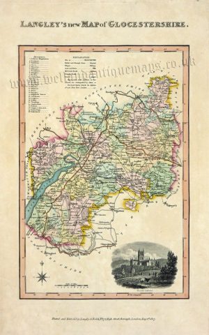
‘LANGLEY’S new MAP of GLOCESTERSHIRE.’ by Langley / Belch c.1817
£
120.00
Add to basket
Add to Wishlist
Add to Wishlist
1
2
→
Home
About Us
Contact Us
Feedback
Recent Additions
Shop Online
Login
Register
Shopping Basket
Scroll to Top

!['A Map of GLOCESTER-SHIRE [Gloucestershire] North West from London' by T. Badeslade / W. H. Toms c.1742](https://www.wellandantiquemaps.co.uk/wp-content/uploads/2023/01/Gloucestershire-Badeslade-01-001-copy-300x285.jpg)

!['A New MAP of GLOCESTER SHIRE [Gloucestershire], Drawn from the best Authorities' by Thomas Kitchin c.1764](https://www.wellandantiquemaps.co.uk/wp-content/uploads/2023/03/Gloucestershire-Glocestershire-Kitchin-Eng-Ill-1764-03-copy-300x233.jpg)


!['GLOCESTERSH.' [Gloucestershire] by 'Reuben Ramble' (Rev. Samuel Clark) c.[1844?] 1845](https://www.wellandantiquemaps.co.uk/wp-content/uploads/2023/01/Glouc-Ramble-001-copy_0-300x380.jpg)


!['GLOCESTERSHIRE' [Gloucestershire] (with full original wash colour) by G. Cole & J. Roper c.1805 / 1810](https://www.wellandantiquemaps.co.uk/wp-content/uploads/2023/01/Gloucestersh-Cole-Roper-03-001-copy_0-300x381.jpg)
!['GLOCESTERSHIRE' [Gloucestershire] by G. Cole & J. Roper c.1805 / 1810](https://www.wellandantiquemaps.co.uk/wp-content/uploads/2023/01/Gloucestershire-Cole-Roper-004-001-copy-300x376.jpg)