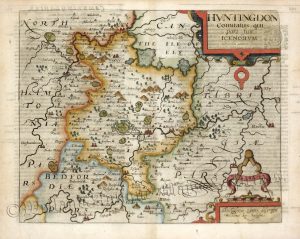
A highly decorative 19th century Thomas Moule map of Huntingdonshire — including attractive vignettes of Hinchinbrooke House and Brampton Park — which was published in Moule’s English Counties Delineated (London: 1836). As well as being a crisp impression from the earlier and less common ‘Moules Counties’ the map is also in rare original hand colour.
The Moule county maps were unusual for the period in that they were highly decorative. The scientific rationality of the late 18th & early 19th century had seen a move away from the flamboyance of earlier map making, emphasizing instead a greater desire for accuracy and detail. Thomas Moule (1784-1851), like many of his contemporaries, however, was drawn to a more simplistic, pre-industrial age. This was clearly reflected in his maps with their neo-Gothic borders, heraldic shields and views of ancient buildings; ironically, the Moule maps issued later in the 1840s were amongst the first to show the newly constructed railways.
- This is an original steel engraving with rare original hand colour.
- Printed area is approximately 20.2cms by 27.2cms.
- The map is in very good condition. The top and bottom margins are close, as issued. The other margins are adequate. Click on image for a better view.
- The item comes displayed in a ready to frame museum quality mount.
- Click on ‘Delivery Policy’ for postage costs.
- Guaranteed to be over 170 years old.