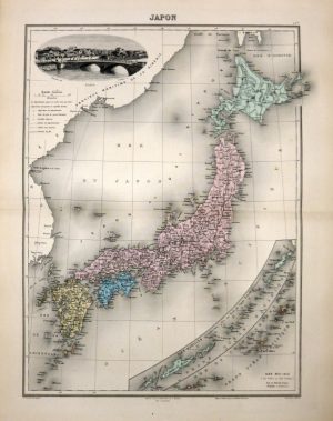
A decorative and detailed mid 19th century map of Japan and Korea which was engraved by J. Rapkin (vignettes by H. Warren & J. H. Kernot) and published in John Tallis’s Illustrated Atlas (London & New York: J. Tallis & co, c.1851/1853).
The Illustrated Atlas, published from 1849 to 1853, was the last decorative world atlas. The ‘Japan & Corea’ map was typical of the many fine ones which appeared in this work with its decorative border and attractive vignettes. Illustrated are views of the City of Yedo (Tokyo), a Japanese state barge and Koreans in their national costume.
- This is an original steel engraving with original & later hand colour.
- Printed area is approximately 33.5cms by 25.4cms.
- The map is in very good condition with decent margins; centrefolded, as issued. Click on image for a better view.
- Click on ‘Delivery Policy’ for postage costs.
- Guaranteed to be over 160 years old.