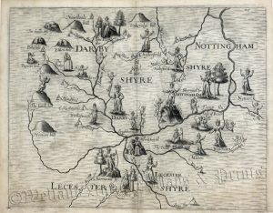
A charming early 17th century county map of Leicestershire which appeared in England, Wales, Scotland and Ireland Described and Abridged… from a Farr Larger Voulume Done by John Speed (London: G. Humble, 1627-1632). Published in a pocket atlas, the map was based on the larger one done by John Speed, hence ‘Miniature Speed’. Unlike many of the maps in the atlas, this wasn’t engraved by Pieter Van Den Keere but by an unknown — probably English — engraver.
- This is an original copperplate engraving with later hand colour.
- Printed area is approximately 12.3 cms by 8.6 cms.
- The map is in very good condition, there is some minor see through from the text on the verso. Click on image for better view.
- The item comes displayed in a ready to frame museum quality mount.
- Click on ‘Delivery Policy’ for Postage costs.
- Guaranteed to be over 375 years old