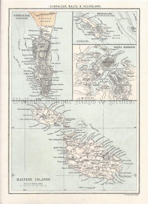
An interesting and detailed early 20th century miniature map of the Maltese Islands which was published in John Bartholomew’s The Handy Atlas of the British Empire (London: George Newnes Ltd, 1904).
- This is an original chromolithograph.
- Printed area is approximately 13.7cms by 8.7cms
- The map is in very good condition with adequate margins. Click on image for a better view.
- The map comes displayed in a ready to frame acid free mount.
- Click on ‘Delivery Policy’ for postage costs.
- Guaranteed to be over 110 years old.

!['DEPT. DE LA CORSE.' [CORSICA] by Victor Levasseur c.1860s](https://www.wellandantiquemaps.co.uk/wp-content/uploads/2023/01/P1090549-copy-300x429.jpg)