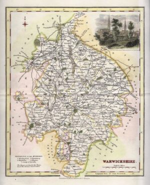
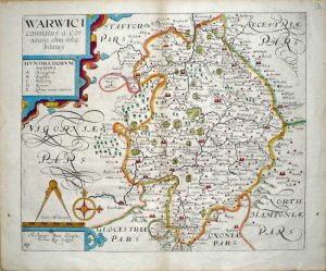
A detailed and decorative 17th century map of Warwickshire which was ‘performed’ by and published in John Speed’s Theatre of the Empire of Great Britaine (London: Bassett & Chiswell, 1676). The inset plans of Warwick and Coventry, probably surveyed by Speed himself, is the earliest known of these towns / cities. On the reverse of the map there is a complete set of text briefly describing the history and topography of the county.
John Speed (1552-1629) was born in the Cheshire village of Farndon and from his youth pursued his father’s profession of tailoring. He later moved to London to continue this trade, though Speed’s real passions lay elsewhere, namely in the fields of antiquity and cartography. He joined the Society of Antiquaries where his enthusiasm soon attracted the attention of notables such as William Camden and Sir Fulke Greville. In 1596 Greville provided Speed with a full time allowance to write a ‘Historie of Great Britaine’. It was during this project that Speed decided to add a cartographic supplement to the work and it was from this that his famous atlas, ‘The Theatre of the Empire of Great Britaine’, was born.
When published in 1611/12, his atlas was an immediate success, outdoing the one established by Christopher Saxton in 1579. There were a number reasons for this: Speed’s atlas showed each county separately with its hundreds, was resplendent with heraldic shields but most significantly had one or two town plans. Displayed from a bird’s eye view perspective, many of the towns were surveyed by Speed himself using a distinct ‘scale of paces’ and are the earliest known plans of these places. The aesthetic beauty of the maps were also down to the Dutch engraver, Jodocus Hondius, whose fine calligraphy and decorative strapwork are a feature throughout.
Speed’s legacy was to live on long after his passing, the Theatre itself was published in many editions until 1676. The maps were then re-published in the early 18th Century by John & Henry Overton and then finally in the 1780s by Dicey & co. giving them a life of 170 years.
- This is an original copperplate engraving with old hand colour.
- Printed area is approximately 51.1cms by 38.3cms.
- The map is in very good condition. The top margin is very close, as was originally issued, but has had a paper border added so can be framed easily. There is also some minor restoration to the central fold. Click on image for a better view.
- Click on ‘Delivery Policy’ for postage costs.
- Guaranteed to be over 340 years old.