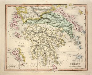
A highly decorative and detailed mid 19th century map of ‘Turkey in Europe’ (The Balkans: northern Greece, Macedonia, Bulgaria, Albania, Serbia, Bosnia-Herzogovina, southern Romania) which was drawn and engraved by J. Rapkin (vignettes by H. Warren & J. Rogers) and published in John Tallis’s Illustrated Atlas (London & New York: John Tallis & co, c.1851).
The Illustrated Atlas, published from 1849 to 1853, was the last decorative world atlas. The ‘Turkey in Europe” map was typical of the many fine ones which appeared in this work with its decorative border and attractive vignettes. Illustrated are views of the Bosphorus and Constantinople (Istanbul), Ali Pasha and a Greek Caloyer.
- This is an original steel engraving with original hand colour.
- Printed area is approximately 32.9cms by 25.8cms.
- The map is in very good condition. The top margin is close, but still mountable without loss. Click on image for a better view.
- Click on ‘Delivery Policy’ for postage costs.
- Guaranteed to be over 155 years old.