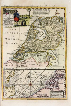
A very attractive and neatly engraved mid 18th century map — with a decorative cartouche — of the United Provinces (The Netherlands) which was engraved by Emanuel Bowen and published in N. Tindal’s The Continuation of Mr Rapin’s History of England (London: 1751).
Emanuel Bowen (fl. 1714-1767) was among the most renowned and prolific map engravers of the 18th century. Along with Thomas Kitchin and his son, Thomas Bowen, he produced some of the finest maps and atlases of the period. His recognition was such that he was appointed Geographer to both George II of Great Britain and Louis XV of France. Despite his many achievements, however, he never enjoyed lasting financial success and died in great poverty.
- This is an original copperplate engraving with later hand colour.
- Printed area is approximately 42.1cms by 34.7cms.
- The map is in very good condition with excellent margins. Click on image for a better view.
- Click on ‘Delivery Policy’ for postage costs.
- Guaranteed to be over 250 years old.