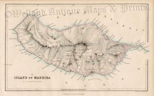
A very attractive 18th century map / sea chart of the Islands of Madeira and Porto Santo (North Atlantic) which was produced by Jacques Nicolas Bellin and published in Antoine-François Prevost’s L’Histoire Générale des Voyages (The Hague: Pierre De Hondt, 1747-1780).
“Jacques Nicholas Bellin (1705-72) spent over fifty years at the French Hydrographic Service where he was appointed the first ‘Ingéieur hydrographe de la Marine’. During his term of office there he was commissioned to carry out major surveys, first of the coasts of France and later of all the known coasts of the world. These tremendous undertakings resulted in the production of a very large number of sea charts of the highest quality which appeared in many editions with varying numbers of charts to the end of the century. He was appointed ‘Hydrographer to the King’ and was a member of the Royal Society in London.” (Moreland & Bannister, ‘Antique Maps’, Phaidon, 1989, p,136).
- This is an original copperplate engraving with later hand colour.
- Printed area is approximately 22.2cms by 16.3cms.
- The engraving is in very good condition with decent margins; centrefold, as issued. There is some minor offset. Click on image for a better view.
- The item comes displayed in a ready to frame museum quality mount.
- Click on ‘Delivery Policy’ for postage costs.
- Guaranteed to be over 250 years old.