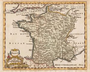
A decorative and detailed mid 19th century map of France was drawn and engraved by John Rapkin (vignettes by J. Wray and J. Rogers) and published in John Tallis & co.’s The Illustrated Atlas (London & New York: c.1851).
The Illustrated Atlas, published from 1849 onwards, was the last decorative world atlas. The France map was typical of the many fine ones which appeared in this work with its ornamental border and attractive vignettes. Illustrated are views of Calais Harbour, the garden of the Palais Royal, the Bridge of Toulouse and the Palace of Fontainbleu.
- This is an original steel engraving with original hand colour.
- Printed area is approximately 31.7cms by 25.5cms.
- The map is in very good condition with decent margins Minor staining which shows up more in the image than in natural light.. Click on image for a better view.
- Click on ‘Delivery Policy’ for postage costs.
- Guaranteed to be over 160 years old.