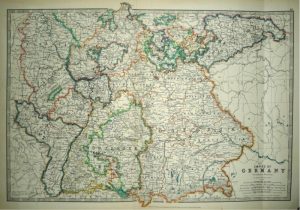
A highly decorative and finely engraved mid 19th century map of Germany which was engraved by J. Rapkin (vignettes by N. Whittock & J. Hughes) and published in John Tallis & co.’s The Illustrated Atlas (London & New York: c.1851).
The Illustrated Atlas, published from 1849 onwards, was the last decorative world atlas. The ‘Germany’ map was typical of the many fine ones which appeared in this work with its decorative border and attractive vignettes. Illustrated are views of Coburg, Dresden, Cologne from the Rhine, the Palace of Saxe-Coburg (birthplace of Prince Albert), Martin Luther’s house in Frankfurt, silver mines in the Hartz mountains and a triple portrait of Guttenburg, Faust and Schoffeer, the ‘inventors of printing’.
- This is an original steel engraving with original hand colour.
- Printed area is approximately 24.9cms by 34.8cms.
- The map is in very good condition. The right margin is close, as issued, but still mountable without loss. Click on image for a better view.
- Click on ‘Delivery Policy’ for postage costs.
- Guaranteed to be over 160 years old.