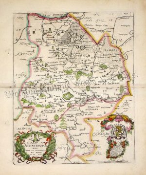
A very attractive and finely engraved 17th century map of Huntingdonshire which was printed and published by Jan Jansson for his Atlas Novus (Amsterdam: [German Text verso] 1649). Jansson was one of the leading Amsterdam map makers during the Dutch ‘Golden Age’, the period in which the Netherlands led the World in commerce, art, science and especially, cartography.
- This is an original copperplate engraving with later hand colour
- Printed area is approximately 50cms by 39.5cms
- The map is in good condition. Slightly age toned (as with all Janssons), good margins, splits to the top and bottom of the centrefold outside the engraved area. There is a minor repaired tear just inside the right border. Click on image for a better view.
- Click on Delivery Policy for postage costs.
- Guaranteed to be over 350 years old.