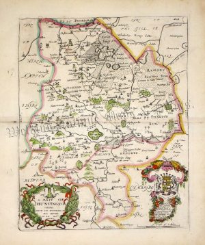
A very rare and attractive early 19th century map of Huntingdonshire which appeared in Darton & Dix’s A Complete Atlas Of The English Counties (London: William Darton & Son, c.1835). The maps from this series are noteworthy for their richness of detail, engraving quality, fine original hand colour and quaint vignette view — in the case of Huntingdonshire, this is of Godmanchester church. Despite their quality, the Darton & Dix maps are amongst the rarest county maps to find and are much sought after by collectors.
- This is an original copperplate engraving with fine original hand colour.
- Printed area is approximately 35.1cms by 44cms (including imprint).
- The map is in very good condition with decent margins; centrefolded, as issued. There is some very minor offset. Click on image for a better view.
- Click on ‘Delivery Policy’ for postage costs.
- Guaranteed to be over 175 years old.