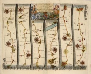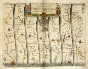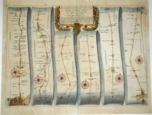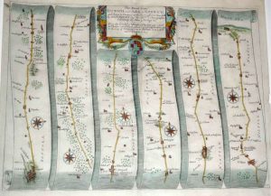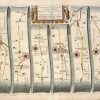
Actual title: ‘The Continuation of the Road from LONDON to BARWICK Beginning at Stilton and extending to Tuxford’.
An attractive and interesting 17th century road strip map showing the route from Stilton to Tuxford — via Stamford, Grantham and Newark — which was published in John Ogilby’s Britannia (London: [Plate 6] 1675 edition). The map can be identified as an early edition as the plate number ‘6’ has not yet been added to the bottom-right border. (The images taken show the map with and without flash).
John Ogilby (1600-1676) was one of the most colourful characters in the history of British map making. Born in Kirremuir, near Dundee he started his working life as a dancer. This career was however cut short when he was injured during a performance. He later moved to Ireland where he established the first ever theatre in Dublin. Having made a considerable fortune out of this he then lost all of it due to the Irish Revolt of 1641 and a shipwreck. Undeterred, he eventually moved to London where he opened a book shop specialising in classical works. He once again amassed a considerable fortune only to see his shop burnt to the ground in the Great Fire of London of 1666. It was then, at the age of 66, that he turned to map making. Having produced maps of Africa, Asia and America, his greatest work, ‘Britannia’, appeared in 1675.This had the distinction of being the first ever road atlas of England & Wales. The 100 maps contained within were also the first to work by the principle of one inch to the mile and to use the Statute mile of 1760 yards (as opposed to the other mile measurements in existence) Each road map depicts a route in the form of 6 or 7 vertical strips with a compass rose showing orientation; additionally, miles, furlongs, towns, churches, windmills, rivers, hills and even gallows are depicted. In total, about 7500 miles were surveyed for the production of the atlas. Britannia proved to be a major success; not only did Ogilby die a wealthy man but his maps were the basis of all road maps for the next 100 years and were incorporated into all county and British maps of the period.
- This is an original copperplate engraving with later hand colour.
- Printed area is approximately 44.3cms by 32.4cms.
- The map is in very good condition with decent margins; centrefolded, as issued. There is overall light age toning with some very minor staining and around the centrefold there are a couple of areas where the paper is naturally thinner but this will not show once framed. Click on image for a better view.
- Click on ‘Delivery Policy’ for postage costs.
- Guaranteed to be over 300 years old.