
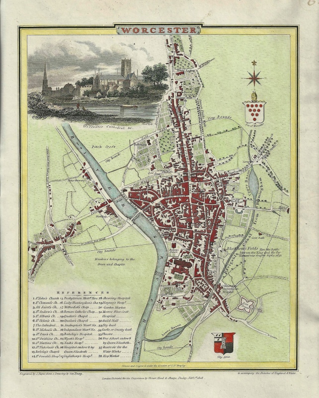
An attractive and interesting early 19th century town plan of Worcester — with a fine vignette view of the Cathedral — which was drawn and engraved by G. Young and John Roper, respectively, and published in the The British Atlas* (London: Vernor, Hood & Sharpe, 1807-1810).
- This is an original copperplate engraving with later hand colour.
- Printed area is approximately 18.8cms by 23.9cms.
- The map is in very good condition with excellent margins. Click on image for a better view.
- The item comes displayed in a ready to frame museum quality mount.
- Click on ‘Delivery Policy’ for postage costs.
- Guaranteed to be over 200 years old.
*The British Atlas, comprising of county maps and town plans, was published as a compendium to Britton and Brayley’s renowned Beauties of England & Wales.


!['WIGORNIENSIS Comitatus et... WARWICENSIS' [Worcestershire & Warwickshire] by J. Blaeu c.1645](https://www.wellandantiquemaps.co.uk/wp-content/uploads/2023/01/Warks-Worc-Blaeu-copy-300x253.jpg)