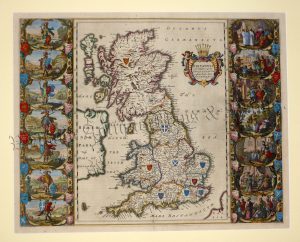
An attractive and ornate early 18th century map of Great Britain and Ireland which was published in Elias Baeck’s Atlas Geographicus (Augsburg: 1710). The plate number ‘5’ in the top right border (first state) dates this map to 1710.
Elias Baeck (1681-1748) was a publisher and engraver in Augsburg, Germany. His Atlas Geographicus was first published in 1710 and contained thirty nine maps. Like most, the one of Great Britain and Ireland had a decorative cartouche, descriptive banner and coats of arms.
- This is an original copperplate engraving with original hand colour.
- Printed area(including green border) is approximately 22.4cms by 16.3cms.
- The map is in very good condition with decent margins; centrefold, as issued. Click on image for a better view.
- The item comes displayed in a ready to frame museum quality mount.
- Click on ‘Delivery Policy‘ for postage costs.
- Guaranteed to be over 300 years old.